|
|
Isle of Man
Sommaire
- Capital :
Douglas
- Coordinates (1) :
25°04 S, 130°06 W
- Population :
80000 inhabitants
- Area : 572 km2
- ZEE (3) : 0 km2
- Currency : Pound sterling
- Population density : 139.9 hab/km2
|
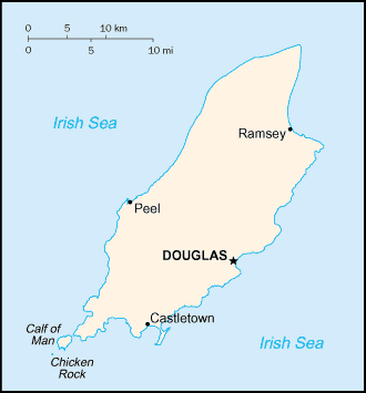
Map of Isle of Man

|
- Administration :
The Isle of Man is a Crown dependancy, possession of The Crown in Right of the United Kingdom, not part of the United Kingdom. The Isle has its own Parliament Tynwald since the 10th Century which votes local laws. However this self-governing island is not sovereign : its status is managed by British Parliament. External relations, money and defence are the responsability of UK.
Top
|
Geography
The official languages on the island are Manx Gaelic and the English. Native speakers of the Manx Gaelic language have temporarily disappeared in the 70's. Today there are again navive speakers thanks to parents who learned the Manx language as a second speaking-language.
- Main towns :
Douglas
- Main islands :
Isle of Man, Calf of Man, Chicken Rock
Top |
Localisation

25°04 S, 130°06 W (1)
Zone :
Top
|
History
The island would have firstly be inhabited by Celtic tribes. Then Irish immigration and Viking settlements contributed to form the identity of the Manx population.
In the Treaty of Perth in 1266, Norway ceded the Isle to Scotland. Next Man will become a British Crown Dependency 1765.
Top
(1) These coordinates are approximate.
(2) Pour ce qui est des TAAF et des îles éparses, ce nombre varie très souvent. Leur population donnée ici n'est donc qu'une approximation très imprécise fournie à titre purement indicatif.
(3) ZEE : Zone économique exclusive. Ces chiffres sont approximatifs.
|
|

 Akrotiri & Dhekelia
 Anguilla
 Ascension Island
 British Antarctic Territory
 Bermuda
 British Indian Ocean Territory
 British Virgin Islands
 Cayman Islands
 Channel Islands
 Falkland Islands
 Gibraltar
 Isle of Man
 Montserrat
 Pitcairn Islands
 Rockall
 Saint Helena
 South Georgia and South Sandwich Islands
 Tristan da Cunha
 Turks and Caicos Islands
 United Kingdom